The numbers back this up. According to MarketsandMarkets, the global agricultural drones market is projected to grow from USD 2.63 billion in 2025 to USD 10.76 billion by 2030 — a 32.6% CAGR. In India, the government's Namo Drone Didi scheme alone is deploying 15,000 drones through women's self-help groups for agricultural rental services across the country.
This guide covers exactly how farmers are using drones right now — the workflow, the applications, the real-world results, and the barriers that still exist (and how they're being cleared).
Key Takeaways
- Agricultural drones handle spraying, mapping, scouting, seeding, and livestock monitoring on farms of all sizes
- They follow GPS-guided flight paths, carry specialized payloads, and feed data back into farm decisions
- Precision spraying is the dominant application — reducing water use and chemical exposure while improving coverage speed
- Drone-as-a-service models let smallholder farmers access these benefits without buying equipment
- Cost, regulation, and data literacy are the main barriers, but all are increasingly manageable through service providers
What Are Agricultural Drones?
Agricultural drones are unmanned aerial vehicles (UAVs) built or adapted for farm use. Depending on the task, they carry spraying tanks, multispectral cameras, LiDAR sensors, or granule spreaders.
Most drones are designed for one of two roles:
- Mechanical tasks — spraying pesticides, broadcasting fertiliser, seeding
- Informational tasks — crop health monitoring, field mapping, yield estimation
Choosing the wrong drone type for the job — say, using a spraying rig for field mapping — leads to poor results and wasted investment. The table below helps match the right tool to the task.
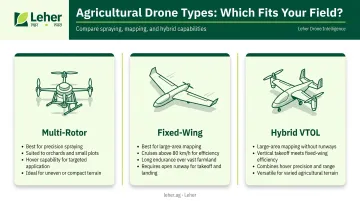
Drone Types Used in Agriculture
| Type | Best For | Notes |
|---|---|---|
| Multi-rotor (quadcopter, hexacopter) | Spraying, close-range monitoring, orchards, small plots | Can hover; ideal for precision work |
| Fixed-wing | Large-area mapping, land surveys | FAO notes these fly above 80 km/h, covering ground quickly |
| Hybrid VTOL | Large-area mapping where runways aren't available | Combines vertical takeoff with fixed-wing efficiency |
Payload capacity has also expanded to match real farm demands. The XAG P150 Max carries an 80 kg payload with an 80 L liquid tank, while the DJI Agras T50 handles 40 kg for spraying and 50 kg for spreading — enough to treat several acres per flight without constant refilling.
How Agricultural Drones Work in the Field
Drone-based farming follows a defined workflow: pre-mission setup, active operation, and post-flight data use. Each stage matters for getting consistent results.
Flight Planning and Setup
The mission starts on the ground. An operator inputs field boundaries and flight parameters into ground control software, which auto-generates a GPS-guided flight grid. Modern systems — including those used with DJI and XAG equipment — support fully autonomous flight, meaning the drone follows its programmed path without manual steering.
Terrain-following technology handles uneven ground automatically. The drone maintains a consistent height above the crop canopy, adjusting for elevation changes across slopes or bunded paddy fields — critical for uniform spray coverage.
Active Operation
During flight, the drone moves along the grid while the payload activates. A spraying drone releases inputs at a controlled flow rate; a monitoring drone captures multispectral imagery at set intervals. GPS tags every action with a precise field location, creating a complete record of where inputs were applied.
Advanced systems add variable-rate application: pre-mapped crop health data tells the drone to apply more fertilizer in deficient zones and less in healthy ones — not a uniform blanket dose across the whole field.
Data Processing and Output
Spraying and monitoring often run in parallel — while one drone applies inputs, another logs crop conditions for analysis. After a monitoring flight, imagery is processed through software that generates NDVI maps (Normalized Difference Vegetation Index). As defined by NASA and USGS, NDVI calculates vegetation health using the ratio of near-infrared to red light reflectance — higher values indicate greener, healthier plants.
The output is practical. Processed maps identify stress zones, nutrient deficiencies, or early disease patches, then feed into:
- Variable-rate prescription maps for the next spray cycle
- Targeted field inspection priorities
- Week-over-week crop progress tracking
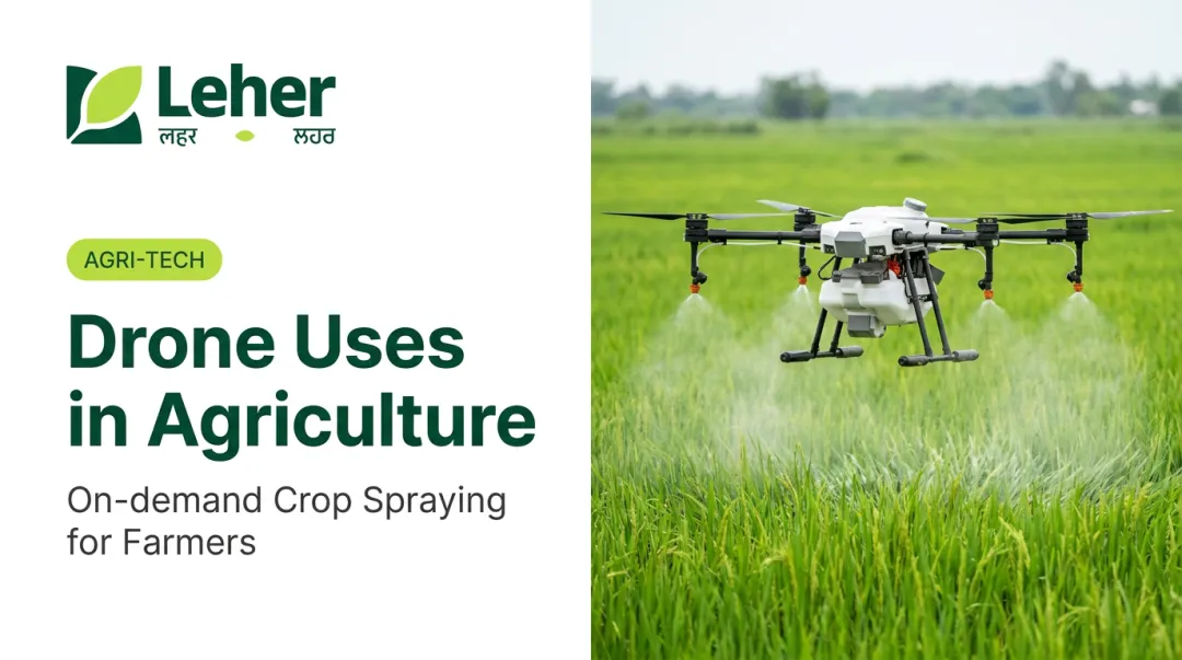
Key Ways Farmers Use Drones Today
Six applications account for the vast majority of drone deployment on working farms.
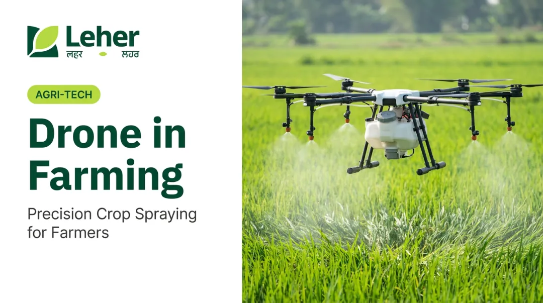
Precision Crop Spraying
Spraying is the single most widespread use of agricultural drones globally — covering pesticide application, liquid fertiliser delivery, and fungicide treatments.
The efficiency advantage over manual methods is substantial. A 2025 peer-reviewed study found drone spraying used just 0.01 m³/ha of water versus 0.3 m³/ha for tractor-mounted sprayers in wheat. On chemicals, UF/IFAS research reports targeted drone herbicide applications can reduce chemical use by up to 30%.
Services like Leher's drone-powered precision spraying — deployed across paddy, cotton, sugarcane, wheat, and plantation crops — have reported reductions of up to 90% in water usage and up to 30% in pesticide use compared to conventional methods. Across 30,000+ acres served and 2,100+ farmers, these aren't theoretical gains.
Drone spraying also removes workers from direct chemical exposure — a meaningful safety improvement, particularly for aging farming populations.
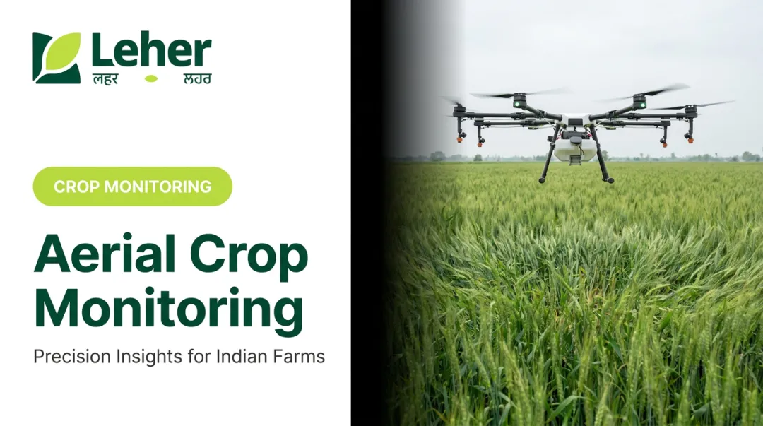
Crop Monitoring and Health Assessment
Multispectral-equipped drones fly regular grid patterns and generate NDVI or similar vegetation index maps. The key value: these maps reveal water stress, nutrient deficiencies, or early disease symptoms weeks before they're visible to the naked eye or cause yield loss.
Catching a fungal spread early costs far less than waiting for visible crop damage.
Field Mapping and Soil Analysis
Drones create high-resolution topographic maps and orthomosaic images of fields, identifying drainage problems, elevation variations, and soil composition zones. These maps feed precision practices like variable-rate seeding or irrigation zone planning — turning aerial data into an actionable management tool.
Seed Sowing and Fertiliser Broadcasting
Drones are increasingly used to broadcast seeds (particularly paddy and cover crops) and dry fertilisers across areas that are waterlogged, steep, or inaccessible to ground machinery.
A 2024 peer-reviewed rice seeding study found drone seeding at 40 kg/ha saved 20 kg/ha of seed versus manual broadcasting at 60 kg/ha, while delivering 13.8% higher grain yield and 22% higher net returns. On the fertiliser side, manufacturer specifications for the XAG P150 list a spreading capacity of 2,167 kg of fertiliser per hour — a scale that explains why adoption of this application is growing quickly.
Pest and Disease Surveillance
Thermal and RGB cameras on scouting drones let agronomists and farmers spot pest hotspots, diseased plant clusters, or weed infestations across entire fields in a single flight. The payoff is targeted spot-treatment rather than field-wide chemical application — reducing costs and limiting environmental impact.
Livestock and Infrastructure Monitoring
For mixed-farming operations, drones count and locate livestock across grazing land, inspect irrigation infrastructure, check fence lines after storms, and assess post-flood crop damage — extending drone value well beyond the growing season.
Real-World Benefits of Drone Use in Farming
Efficiency and Time Savings
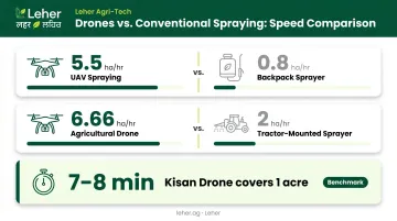
The speed gap between drones and manual labour is significant. Research data shows:
- UAV spraying: 5.5 ha/hr versus backpack sprayer: 0.8 ha/hr
- Drone spraying: 6.66 ha/hr versus tractor-mounted sprayer: 2 ha/hr
- India's PIB benchmark: Kisan drones cover one acre in 7-8 minutes
Leher's operational data aligns with this: a single drone covers up to 50 acres per day — completing in one day what traditional manual methods take over two weeks to achieve with multiple labourers.
Input Cost Reduction
Precision application means inputs go where needed, not everywhere. Concrete figures from the research:
- Up to 30% reduction in chemical use through targeted drone herbicide application
- Variable-rate systems improve nutrient use efficiency by 15% to 25%
- Water volume drops from 249-351 L/ha (tractor/boom) to approximately 11 L/ha (UAV)
Worker Safety and Rural Employment
Drone spraying keeps operators away from chemical exposure entirely. For farmers who previously wore backpack sprayers for hours in hot fields, that's a direct reduction in pesticide-related health risks.
Beyond safety, drone adoption is reshaping rural employment. Operations create new skilled roles that didn't exist in traditional farming:
- Certified drone pilots
- Field data analysts
- Equipment technicians and maintenance crew
These positions make agriculture more attractive to younger rural workers — a critical shift as India's farming workforce ages.
Barriers to Drone Adoption — and How Farmers Are Overcoming Them
Cost and Access
Purchasing a high-specification agricultural spraying drone in India typically starts from around ₹5.5 lakh for a 10 L spraying tank model (Garuda Aerospace), with the broader market ranging from approximately ₹5 lakh to ₹25 lakh depending on capacity and features.
The practical solution for most farmers is the drone-as-a-service model — paying per acre rather than owning equipment. Tamil Nadu's AED/TNAU lists an official drone rental rate of ₹800 per acre, while market providers like Leher report service ranges of ₹300–700 per acre. At these rates, even a 5-acre smallholder can access precision spraying without capital investment.
Government schemes help on the supply side: the Namo Drone Didi program provides drones to 15,000 women's SHGs for agricultural rental services, while ICAR and KVK demonstrations have received financial assistance of ₹10 lakh per drone.
Regulatory Requirements
Under India's Drone Rules 2021, drone operators must obtain DGCA certification and register their aircraft through the Digital Sky platform. For farmers hiring a professional drone service, the compliance burden sits with the operator, not the customer:
- The service provider's pilot holds the Remote Pilot Certificate
- Aircraft registration happens through Digital Sky — handled by the operator
- The farmer books a session; the operator manages all compliance
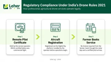
Leher's drone partners are DGCA-certified, so farmers using the platform never have to navigate this process personally.
Data Literacy and Integration
Compliance is one hurdle; making sense of the data is another. Drone-generated NDVI maps and crop health imagery are only useful if someone can interpret them and translate findings into field actions — and many farmers, particularly those without dedicated agronomic support, find raw data hard to act on.
Full-service providers are addressing this by bundling data interpretation with the spraying session itself. Leher, for instance, pairs drone application with post-service crop health feedback, so farmers receive a recommendation alongside results — not just a dataset they have to decode independently.
Conclusion
Drones are not emerging technology in Indian agriculture — they are a working tool that thousands of farmers are already scheduling alongside ploughing and harvest. The practical question now is straightforward: how do farmers access them without bearing the full cost of ownership?
For most smallholder and mid-scale farmers, drone-as-a-service is the answer. Providers like Leher give farmers direct access to precision spraying across paddy, cotton, wheat, sugarcane, and plantation crops — without buying equipment, obtaining a pilot licence, or managing any data infrastructure. As drone networks expand district by district, more farmers are booking their first session and seeing the difference within a single crop cycle.
Frequently Asked Questions
What drones are used in agriculture?
Multi-rotor drones (quadcopters and hexacopters) dominate for spraying and close-range monitoring, while fixed-wing drones are preferred for large-area mapping and surveys. DJI Agras and XAG are among the most widely used brands on working farms globally.
What are the five uses of drones in agriculture?
The five most common uses are precision spraying, crop health monitoring, field mapping and soil analysis, seed and fertiliser broadcasting, and pest and disease surveillance. Livestock and infrastructure monitoring is an emerging sixth application across mixed-farming operations.
How much does drone spraying cost per acre in India?
Tamil Nadu's official AED/TNAU rate is ₹800 per acre, while market providers report ranges of ₹300–700 per acre depending on crop, location, and service. This is generally comparable to or lower than hiring manual labour for the same task, with the added benefit of significantly faster coverage.
Do farmers need a licence to use agricultural drones in India?
Under India's Drone Rules 2021, the drone operator must hold DGCA certification and register the aircraft. Farmers who hire a professional drone service provider do not need a personal Remote Pilot Certificate — the licensed operator manages all regulatory requirements.
Can small farmers with limited land benefit from agricultural drones?
Yes. Drone-as-a-service models — like app-based booking platforms where farmers pay per acre after the job is done — keep costs affordable even for fragmented smallholder plots of 2–5 acres.
How do drones reduce water and chemical use in farming?
Drones apply inputs in low volumes with precise, GPS-guided targeting — using approximately 11 L/ha of spray solution versus 250–350 L/ha for conventional ground sprayers. That's up to 90% less water and a meaningful reduction in the quantity of active ingredients applied per hectare.