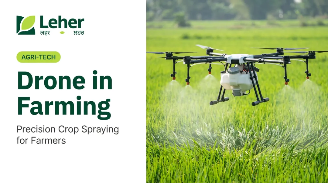
Introduction
Indian farming is under pressure from multiple directions at once. With 146 million farm holdings averaging just 1.08 hectares — and 86% classified as small or marginal — farmers are navigating groundwater depletion, rising input costs, and shrinking agricultural labour supply simultaneously.
The health toll of pesticide overuse compounds the problem. A Southern India study found that 40% of pesticide sprayers showed peripheral sensory neuropathy symptoms, compared to just 9.1% in other occupations.
Drone technology is emerging as a practical answer to these compounding problems — through accessible on-demand services, government-backed programmes, and a growing network of rural drone entrepreneurs who bring the equipment directly to the farm.
This article covers the major applications of agricultural drones, how they specifically benefit Indian farmers, and why the technology is becoming accessible at scale.
Key Takeaways
- Drones support crop monitoring, precision spraying, field mapping, seeding, and livestock management — with spraying leading current adoption
- A 2025 Northern India study found UAV spraying used 70% less water and 40% less pesticide than conventional methods
- Drone-as-a-Service (DaaS) models remove the equipment ownership barrier for smallholder farmers
- Government subsidies (up to ₹5 lakh for small/marginal farmers) and schemes like Namo Drone Didi are bringing drone access to more smallholder farmers
- Rural drone entrepreneurship creates skilled local jobs, keeping economic value within farming communities
Key Applications of Drones in Agriculture
Crop Monitoring and Health Assessment
Drones equipped with multispectral cameras and NDVI (Normalised Difference Vegetation Index) imaging detect crop stress, pest infestations, and nutrient deficiencies before they're visible at ground level. A peer-reviewed wheat study found that NDVI deviations from UAV imagery could be registered up to 10 days before visible-range changes appeared — giving farmers a window to intervene before problems compound.
Traditional scouting requires walking large fields over multiple days, often missing early-stage issues in difficult terrain. Drone-based monitoring addresses this directly:
- Covers large fields in a fraction of the time required for manual scouting
- Delivers millimetre-level imaging accuracy across the entire field
- Generates consistent, comparable data across every survey pass
- Flags stress zones and deficiencies in difficult or uneven terrain
Precision Spraying and Fertiliser Application
GPS-guided drone sprayers follow pre-programmed flight paths to deliver uniform pesticide and fertiliser coverage across the crop canopy — eliminating overlap, missed patches, and excess chemical use. The propeller downwash from multi-rotor drones forces droplets deep into the canopy, improving penetration compared to ground-based methods.
The health implications of conventional spraying are well-documented. Backpack sprayers require workers to carry and directly apply toxic chemicals across entire fields, with direct chemical exposure across every application. According to research on pesticide sprayers in Southern India, sprayers showed a mean peak expiratory flow of just 346 L/min versus 390 L/min in non-sprayers. That measurable respiratory gap is exactly what drone adoption can help close — a single certified pilot operates from a safe distance, removing direct exposure from the equation entirely.
Field Mapping, Soil Analysis, and Seeding
Field mapping: Drones equipped with GPS, LiDAR, or photogrammetry (aerial image-based mapping) payloads generate high-resolution topographic maps, identify drainage patterns, and assess soil moisture across a field. This data enables smarter irrigation decisions and more targeted field management.
Drone seeding: Research from a 2024 rice study found that drone seeding at 40 kg/ha produced a 13% higher yield than manual broadcasting at 60 kg/ha while using 20 kg/ha less seed — a meaningful efficiency gain. ICAR-IIRR and Jayashankar Telangana State Agricultural University have both tested drone-based direct rice seeding in Indian field conditions, validating the approach for difficult or waterlogged terrain.
Livestock Monitoring and Farm Security
Thermal-equipped drones locate and count livestock across large grazing areas, detect injured or sick animals via heat signatures, and monitor farm perimeters — replacing hours of manual patrolling with a single flight. In India, this application is gaining ground among larger dairy operations, plantation agribusinesses, and integrated farming enterprises where herds are spread across hundreds of acres and manual head-counts are both time-consuming and error-prone.
How Drones Are Transforming Indian Agriculture
The Scale of the Problem
India's agricultural challenges are structural, not seasonal. With average monthly income per agricultural household at just ₹10,218 in 2018-19, thin margins leave no room for waste. India is also the world's largest groundwater user, extracting roughly 251 km³ annually — a level of extraction that is simply not sustainable. Pesticide overuse compounds the problem, with chemicals applied across 25% of cultivated land.
For most smallholders, the real need is not owning a drone — it is accessing drone services at a price that makes economic sense.
India's Policy and Regulatory Environment
India has built a supportive regulatory framework for agricultural drones:
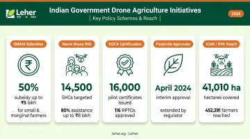
- SMAM subsidies: Small, marginal, and women farmers receive a 50% subsidy up to ₹5 lakh for drone acquisition; ICAR/SAUs/KVKs receive 100% grants up to ₹10 lakh
- Namo Drone Didi: Targets 14,500 women Self-Help Groups during 2024-26 with 80% assistance up to ₹8 lakh, enabling SHG-led drone rental services
- DGCA certification: As of July 2024, 16,000 remote pilot certificates had been issued across 116 RPTOs, with 70 type-certified UAS models approved
- Pesticide approvals: PPQS/CIBRC extended interim approval for existing approved pesticide formulations through drones for one year from April 2024
- Demonstrated reach: ICAR/KVK demonstrations have covered 41,010 hectares, benefiting 452,291 farmers from 2023-24 through November 2025
This combination of subsidies, institutional support, and progressive regulation makes India one of the more accessible environments globally for agricultural drone adoption.
The DaaS Model: Access Without Ownership
Drone-as-a-Service removes the single biggest barrier for smallholders: capital cost. Instead of purchasing and maintaining equipment, farmers simply book a spraying session. A trained, certified pilot arrives, sprays the field, and payment follows after the job is done — no upfront investment required.
Leher's platform works precisely this way. Through the Leher App, a farmer books drone spraying in three steps, a DGCA-certified pilot handles the entire operation, and the farmer pays only after completion. This pay-after-service model reduces financial risk and builds trust with first-time users. The results are measurable: up to 90% water savings, around 40% input savings, and coverage of up to 50 acres per day — compared to roughly 3 acres per day with manual methods.
In 2024 alone, Leher served 6,500+ acres and supported 810+ farmers across crops including paddy, sugarcane, cotton, wheat, and vegetables — as well as specialised plantation operations covering 700+ hectares of tea and 1,000+ hectares of rubber.
Rural Drone Entrepreneurship
DaaS also creates skilled rural employment, not just farm efficiency gains. Leher's Drone Partner Program recruits rural entrepreneurs as certified drone operators, providing AIF loan facilitation, drone insurance, annual maintenance contracts, 24/7 technical support, and guaranteed orders through the platform. Leher currently has 100+ active drone partners, with a target of 1,000 rural drone partners by 2030.
The government's Namo Drone Didi scheme reflects the same logic: SHG participants in one reported case earned over ₹5 lakh in a year from drone spraying services. That income stays within the village rather than flowing to distant service providers.
The Real Benefits Drone Technology Delivers for Farmers
Reduced Input Costs
Precision application directly reduces the volume of water, pesticide, and fertiliser used per acre:
- ~90% water savings versus conventional ground-based spraying
- ~30–40% reduction in pesticide/input use through targeted delivery
- ~20% overall cost reduction in farming operations
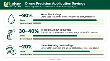
For smallholder farmers operating on thin margins, these savings can shift an entire season from loss to profit.
Productivity and Yield Improvement
Drones improve yields at multiple points in the crop cycle:
- Early stress detection via NDVI imaging lets farmers intervene before problems escalate
- Rice seeding trials showed 13% higher yields than manual broadcasting, at lower seed rates
- Uniform spray coverage eliminates missed patches and overdosed zones — especially critical for pest-sensitive crops like cotton
Environmental Protection
Targeted application means less chemical drift, less runoff into surrounding soil and water bodies, and a lower pesticide load on nearby soil, water, and wildlife. With pesticides already applied across 25% of India's cultivated land, any reduction in unnecessary chemical use supports long-term land health and biodiversity.
Worker Safety
Replacing backpack sprayers with drones eliminates direct farmer exposure to hazardous agrochemicals. The health data from Southern India is stark — 27% of pesticide sprayers reported breathlessness during daily activities versus 10.6% in other occupations. Drone spraying removes the operator from the spray environment entirely.
Challenges in Adopting Agricultural Drones
Awareness and Upfront Cost
Most Indian smallholders cannot afford to purchase and maintain an agricultural drone, which can cost ₹8–10 lakh or more. DaaS models and government-subsidised CHC rentals address the ownership barrier — but awareness of these options remains low in many rural areas. Expanding knowledge of booking platforms and service providers is as important as the technology itself.
Regulatory and Certification Requirements
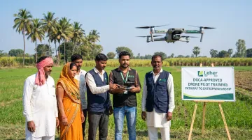
Drone operators must navigate DGCA licensing, remote pilot certification, and airspace regulations. This creates a knowledge gap in rural areas where aspiring drone entrepreneurs need structured training and ongoing support. Leher's DGCA-approved Drone Pilot Training programme addresses this by offering both online and in-person options with job placement support — making certification accessible beyond urban training centres.
Data Literacy and Technology Readiness
Drone-generated data — NDVI maps, prescription spraying zones, flight logs — only delivers value when farmers can understand and act on it. Three elements make adoption practical at the ground level:
- Language-accessible interfaces that don't assume literacy in a single language
- Simplified booking flows (Leher's app uses OTP-only registration and post-service payment)
- Community support through FPOs and local service networks
Scaling this across India's linguistic and digital diversity still requires sustained effort from service providers, government, and FPOs alike.
The Future of Agricultural Drones in India
The global agricultural drone market is on a steep growth trajectory. MarketsandMarkets projects the market to grow from USD 2.63 billion in 2025 to USD 10.76 billion by 2030, a 32.6% CAGR. A separate Mordor Intelligence estimate puts the figure at USD 3.9 billion by 2031. The two forecasts diverge significantly in scale, but the direction is consistent: rapid expansion driven by crop spraying, which is currently the fastest-growing segment at an 18.4% CAGR.
For Indian farmers, the practical implications of market growth are:
- Lower service costs as competition increases and hardware improves
- Wider coverage as more rural drone entrepreneurs enter the market
- Smarter applications as AI-powered crop analysis, prescription mapping, and adaptive spraying become standard features rather than premium add-ons
The next generation of drone technology — field-specific prescription maps, autonomous multi-drone coordination, and farm management software integration — is already in research-stage deployment. Within five years, these tools are set to reach Indian farmers through service providers, not just large-scale agribusinesses. Government infrastructure is keeping pace: the Namo Drone Didi IT portal now tracks live drone operations and usage data nationwide, creating a foundation for data-driven crop management that benefits operators and farmers alike.
Frequently Asked Questions
What are the applications of drones in agriculture?
Drones are used for crop monitoring, precision spraying, field mapping, seeding, and livestock monitoring. Spraying and monitoring account for the vast majority of current applications globally, with crop monitoring holding a 48% application share in 2025 and spraying growing fastest at an 18.4% CAGR.
How are drones used in Indian agriculture?
In India, drones are primarily used for precision spraying of pesticides, foliar fertilisers, and weedicides. Adoption is growing under SMAM subsidies, the Namo Drone Didi scheme, and Drone-as-a-Service models — where operators like Leher connect trained pilots with farmers via app-based booking — making professional spraying accessible to smallholder farmers without equipment ownership.
What are the benefits of using drones in farming?
Key benefits include:
- Reduced input costs through targeted, waste-free application
- Early crop health detection via NDVI imaging
- Improved yields from timely, uniform coverage
- Lower environmental impact compared to conventional spraying
- Safer working conditions, with no direct farmer exposure to agrochemicals
How do agricultural drones reduce pesticide and water use?
GPS-guided flight paths eliminate over-spraying and missed patches, while drone-specific nozzle technology delivers uniform fine droplets precisely where needed. A 2025 Northern India study recorded 70% lower water use and 40% lower pesticide consumption versus conventional methods.
Can small farmers in India afford drone technology?
Most smallholders access drone services through DaaS providers or government-supported CHC rentals rather than purchasing equipment. Booking platforms like the Leher App allow farmers to pay per session, only after the job is completed — making per-acre costs competitive with conventional spraying.
What is the future of drone technology in Indian agriculture?
The global ag drone market is projected to reach USD 10.76 billion by 2030. In India, continued government support, crop analysis software, and an expanding network of trained rural drone operators are expected to lower service costs and extend coverage to farmers nationwide.