The frustrating reality: many of these losses are avoidable. Disease, pest pressure, nutrient deficiencies, and water stress all leave detectable signals before they cause serious damage — if farmers have the right tools to see them.
Crop health monitoring is how you close that gap. Modern tools — from freely available satellite imagery to drone-mounted cameras to IoT soil sensors — now make it possible for farmers to detect stress early, apply inputs precisely, and protect yields before losses compound. What was once the domain of large agribusinesses is increasingly accessible to smallholder farmers across India.
This guide covers the key tools, the core techniques, and how to put them together practically.
Key Takeaways
- Pest, disease, and nutrient deficiency cause major crop losses across India — most are preventable with early detection
- A layered monitoring stack — satellite imagery (including free options like Sentinel-2), drones with multispectral cameras, IoT sensors, and AI platforms — gives farmers visibility at every scale
- NDVI and related vegetation indices translate aerial data into readable crop health indicators
- For India's fragmented smallholder farms, drones cover multiple small plots quickly while delivering field-level precision
- Drone-as-a-service providers like Leher give farmers access to this technology without the cost of owning equipment
What Is Crop Health Monitoring and Why Does It Matter?
Crop health monitoring is the systematic, ongoing observation and analysis of crops to detect stress signals — disease, pests, nutrient deficiencies, water stress, and weed pressure — before they cause significant yield loss. Early detection keeps problems treatable rather than catastrophic.
Three outcomes make it worth the investment for Indian farmers:
- Earlier problem detection that limits how far disease or pest pressure spreads before treatment
- Smarter input use — water, fertiliser, and pesticides applied where they're actually needed, reducing waste and cost
- More consistent yields that improve farm income across seasons, not just good years
Technology-enabled monitoring is rapidly replacing manual field walking across India — and this shift is accessible without large-farm budgets. With 146.45 million operational holdings averaging just 1.08 hectares (Agriculture Census 2015-16), the tools that matter most are those delivered through shared services, FPOs, and pay-per-use models.
Key Tools for Crop Health Monitoring
No single tool covers everything. The best monitoring setup is layered — each technology contributes data the others can't. (Retaining this em-dash as the strongest instance in the section.)
Satellite Imagery and Remote Sensing
Satellites capture large-scale aerial views across entire farm regions and use spectral data to reveal crop stress that's invisible to the naked eye. For farmers managing multiple plots or large areas, satellites offer the most cost-effective first screening available.
Free vs. paid options:
| Platform | Resolution | Revisit Frequency | Cost |
|---|---|---|---|
| Sentinel-2 | 10 m, 13 spectral bands | Every 5 days | Free |
| Landsat 8 | 30 m multispectral | Every 16 days | Free |
| Commercial providers | Sub-metre | Daily or on-demand | Paid |
Sentinel-2's 5-day revisit and 10-metre resolution make it the practical starting point for most Indian farmers. One limitation: during the kharif monsoon season, cloud cover significantly impairs optical satellite imagery. Sentinel-1 SAR (Synthetic Aperture Radar) addresses this gap, capturing images in all weather conditions, day and night, making it useful for rice monitoring through the growing season.
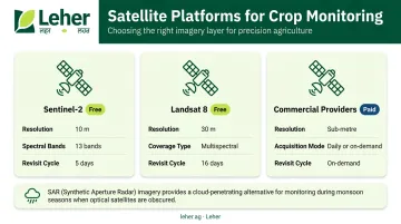
India's own FASAL programme and the Krishi-DSS geospatial platform demonstrate that government agencies already rely on this freely available satellite data for national crop mapping, achieving 80–95% crop-map accuracy across states.
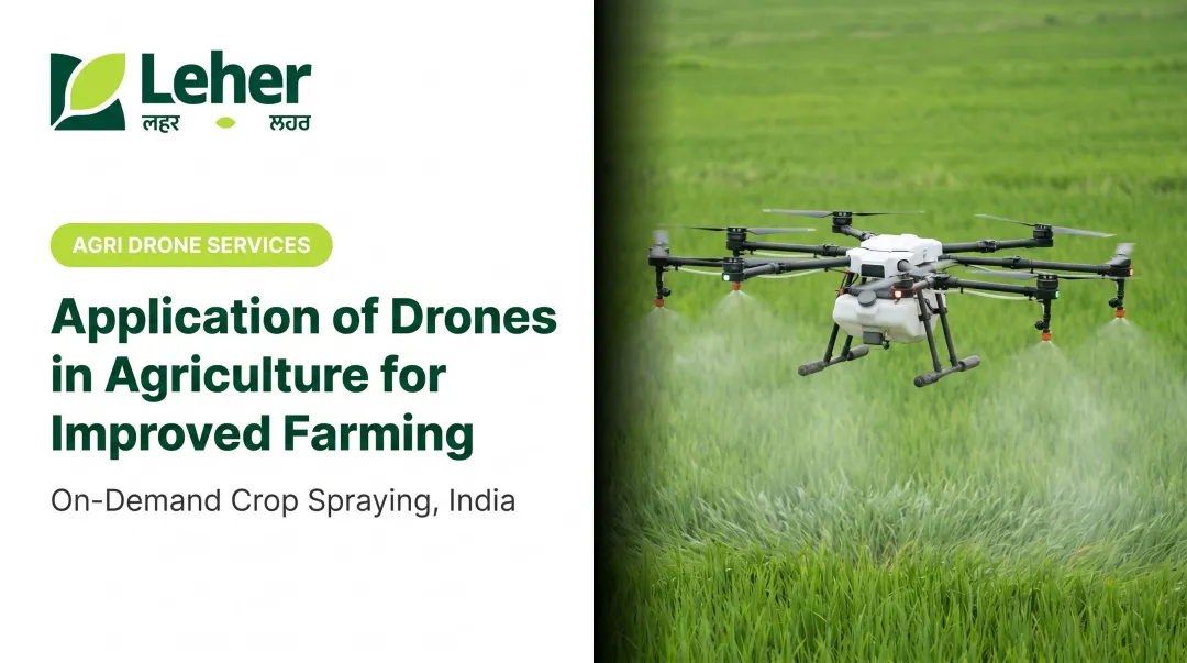
Drones with Multispectral Cameras
Where satellites give you the field-wide picture, drones fill in the details. Equipped with multispectral or thermal cameras, drones capture field-level data at resolutions satellites can't match , identifying pest hotspots, disease patches, and nutrient stress zones with precision down to individual plant rows.
For India's fragmented smallholder farms, drones have a practical edge: they can cover multiple small, adjacent plots in a single session, work independently of internet connectivity, and capture imagery during narrow growth-stage windows that weekly or bi-weekly satellite passes might miss entirely.
A 2025 peer-reviewed study found that AI-drone systems combining multispectral imagery with environmental sensor data achieved 94.2% accuracy for early crop disease detection , a strong signal of where the technology is heading.
Services like Leher remove the equipment barrier entirely. Farmers book a session through the Leher App, a DGCA-certified pilot arrives and completes the job, and payment happens only after the work is done — no drone ownership required.
IoT Sensors and Soil Probes
Aerial tools show you where stress is occurring. In-field IoT sensors (soil moisture probes, temperature monitors, humidity sensors) tell you why, providing continuous, real-time ground-level data that guides irrigation and input decisions.
The evidence on savings is concrete: ICAR-NRC Banana's research found that IoT-enabled soil-moisture scheduling reduced water use by 25–30% and nutrient application by 15–20% without compromising yield. A separate study on automated sensor-based irrigation systems reported application efficiency of up to 86.6%.
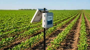
IoT sensors work best in irrigated, high-value crop contexts where the cost of installation is justified by measurable savings.
AI-Powered Farm Management Software
Raw data from satellites, drones, and sensors only becomes useful when it's analysed. AI platforms take this data, identify patterns, flag anomalies, generate alerts, and can predict disease outbreaks before they're visible in the field.
India has working examples at scale. Wadhwani AI's models are integrated into ICAR-NCIPM's National Pest Surveillance System for cotton pest identification. CropIn's DEWS platform uses weather and disease-history data across 65+ disease models covering 20+ crop variants. These tools don't replace agronomists; they help advisors scale their reach and respond faster.
Essential Monitoring Techniques Explained
NDVI and Vegetation Indices
NDVI (Normalised Difference Vegetation Index) is the most widely used crop health measurement. It calculates the ratio of near-infrared to red light reflected by plants — healthy vegetation absorbs red light and reflects near-infrared strongly, so a high NDVI indicates healthy growth, while a low value signals stressed or damaged crops.
But NDVI isn't always the right index. Here's when to use alternatives:
| Index | Best Use Case |
|---|---|
| NDVI | General vegetation health, change detection |
| EVI | Dense crops or high atmospheric interference (monsoon season) |
| GNDVI | Nitrogen stress and photosynthetic activity assessment |
| SAVI | Sparse crop cover or exposed soil conditions |
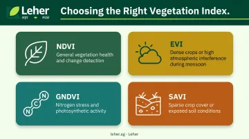
For Indian conditions, EVI is particularly relevant during the kharif season when monsoon cloud cover and dense biomass can make standard NDVI less reliable.
Thermal Imaging for Water and Heat Stress
Thermal cameras detect surface temperature variations across a field. The principle is straightforward: well-watered crops cool themselves through transpiration. Water-stressed crops close their stomata, reducing evaporative cooling — so they appear warmer in thermal imagery.
A 2024 review confirmed that thermal imaging is more reliable than standard RGB photography for detecting crop moisture stress. For Indian farmers dealing with uneven water distribution across large or fragmented plots, thermal mapping can identify exactly where irrigation is needed — rather than applying water uniformly across the entire field.
Visual Scouting Supported by Digital Tools
Manual scouting — physically walking fields and inspecting plants — remains valuable. No technology fully replaces the information a trained eye gathers at ground level. What changes is how that information gets recorded and used.
Mobile apps now turn a single scouting walk into structured, traceable data. A good field scouting app will:
- Diagnose disease from photos using AI image recognition
- Geo-tag problem spots on a field map for precise relocation
- Log observations with timestamps for season-over-season comparison
- Surface recurring patterns across multiple visits that single-session scouting would miss
Data Integration and Calibration
The most important principle in crop health monitoring: don't rely on any single data source.
Satellite or drone imagery might flag a zone as stressed, but that signal needs ground-truth confirmation. Is it disease? Waterlogging? A soil compaction issue? Cross-validating aerial data with soil sensor readings and a physical field check reduces false alerts and improves the quality of decisions.
Monitoring creates value only when it drives action. Before deploying any monitoring system, define your response protocol:
- Trigger: At what NDVI threshold (or temperature deviation) does an alert get raised?
- Owner: Who is responsible for the follow-up field check?
- Timeline: Within how many days must the zone be inspected?
- Response: What treatment gets applied once the problem is confirmed?
Connecting detection to response is what turns monitoring from an information exercise into a yield-protection system.
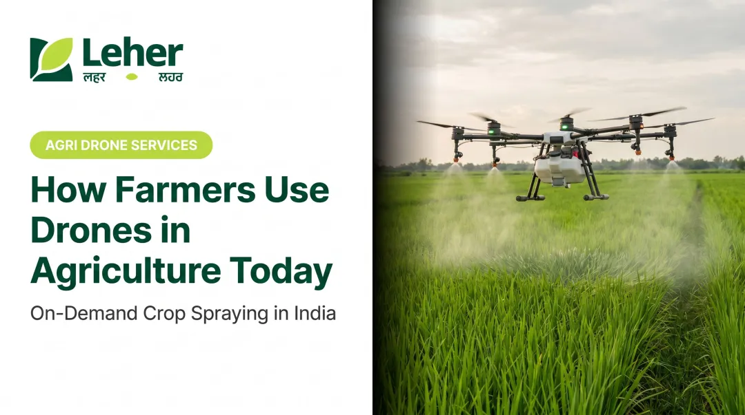
How Drones Are Changing Crop Health Monitoring in India
India's agricultural structure creates specific conditions where drones outperform most alternatives. With average holdings under 1.1 hectares, monitoring tools need to handle fragmented, non-contiguous plots efficiently — not optimise for continuous large fields.
Drones handle this well. A single session can cover multiple scattered plots, operate without internet connectivity in rural areas, capture imagery during growth-stage-critical windows, and flag issues that satellite revisit schedules would miss entirely.
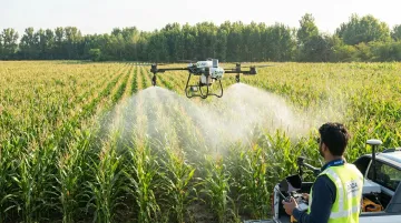
The connection between monitoring and action is where drones offer their clearest advantage. Once a pest hotspot or nutrient-deficiency zone is identified through aerial imagery, precision spraying targets exactly that area — not the entire field.
Leher's drone spraying operations demonstrate this in practice: covering up to 50 acres per day, completing one acre in approximately 5 minutes, with claimed water savings of around 90% and input savings of around 40% compared to conventional methods.
For smallholder farmers, the bigger shift is economic access. India now has 29,501 registered drone UINs and 65 agriculture-specific DGCA type certificates as of early 2025 — an emerging service ecosystem rather than a farmer-owned equipment market. Government policy reinforces this access through targeted funding:
- SMAM grants: up to 75% subsidy for FPO drone demonstrations
- Namo Drone Didi programme: targets 15,000 drones for women's Self-Help Groups with 80% financial assistance
Drone-as-a-service providers make this ecosystem practical. Through platforms like Leher, farmers book professional spraying sessions without owning equipment, managing maintenance, or training pilots — removing the main barriers to adoption for the smallholder majority.
How to Set Up a Crop Health Monitoring System
A practical four-step approach for Indian farmers:
Assess your farm's primary challenges. Identify whether water stress, pest pressure, or nutrient deficiency is your biggest loss driver — and at what scale. This determines which tools justify the cost.
Choose a layered combination of tools based on your farm's size and primary risk:
- Satellite imagery (Sentinel-2 is a free starting point) for field-wide overview
- Drone surveys for detailed inspections of flagged areas
- Soil sensors where irrigation precision matters most
Establish a monitoring schedule. At minimum, monitor at each major crop growth stage: germination, vegetative growth, flowering, and maturity. Heavy rain, dry spells, and hailstorms all create rapid stress conditions — each warrants an unscheduled check.
Build a response protocol before you need it. Define what action follows each monitoring trigger. If NDVI drops below a threshold in a zone, inspection happens within a fixed number of days. If thermal imaging flags water stress in a block, that block gets irrigated first. Without a clear action chain, monitoring data stays on a dashboard — and losses continue.
Common Challenges and How to Overcome Them
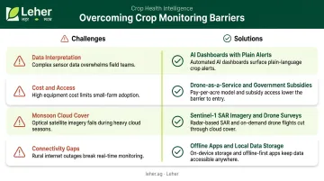
Four challenges come up repeatedly when farmers and agribusinesses try to operationalize crop health monitoring. Here's what causes each one — and what actually works:
- Data interpretation: Farmers collect data but lack tools to act on it. Platforms with automated alerts and simple visual dashboards cut through this — AI advisory tools like Wadhwani AI's pest monitoring system work because they translate complex outputs into plain recommendations.
- Cost and access: Hardware ownership is no longer the only path. Drone-as-a-service providers offer pay-per-use models, and government schemes under SMAM and Namo Drone Didi provide subsidies for FPOs and SHGs acquiring drones for shared use.
- Monsoon cloud cover: Optical satellite imagery becomes unreliable during the kharif season. Sentinel-1 SAR imagery is the practical alternative — it captures reliable data through cloud cover. Drone surveys during clear-weather windows between monsoon spells also work well.
- Connectivity gaps: Rural tele-density stood at 59.06% as of March 2025, meaning roughly 4 in 10 rural locations still face constraints. Offline-capable apps and local data storage keep field scouting and sensor logging functional without a live connection.
Frequently Asked Questions
What is crop health monitoring?
Crop health monitoring is the ongoing process of observing and analysing crops for signs of stress — including disease, pests, nutrient deficiencies, and water issues. It combines tools like satellites, drones, and sensors with field scouting so farmers can act before damage spreads.
What is the crop monitoring process?
The process runs in a repeating cycle: assess farm needs → collect field data (satellites, drones, sensors, manual scouting) → analyse for stress or anomalies → take targeted corrective action. This cycle repeats at key crop growth stages throughout the season.
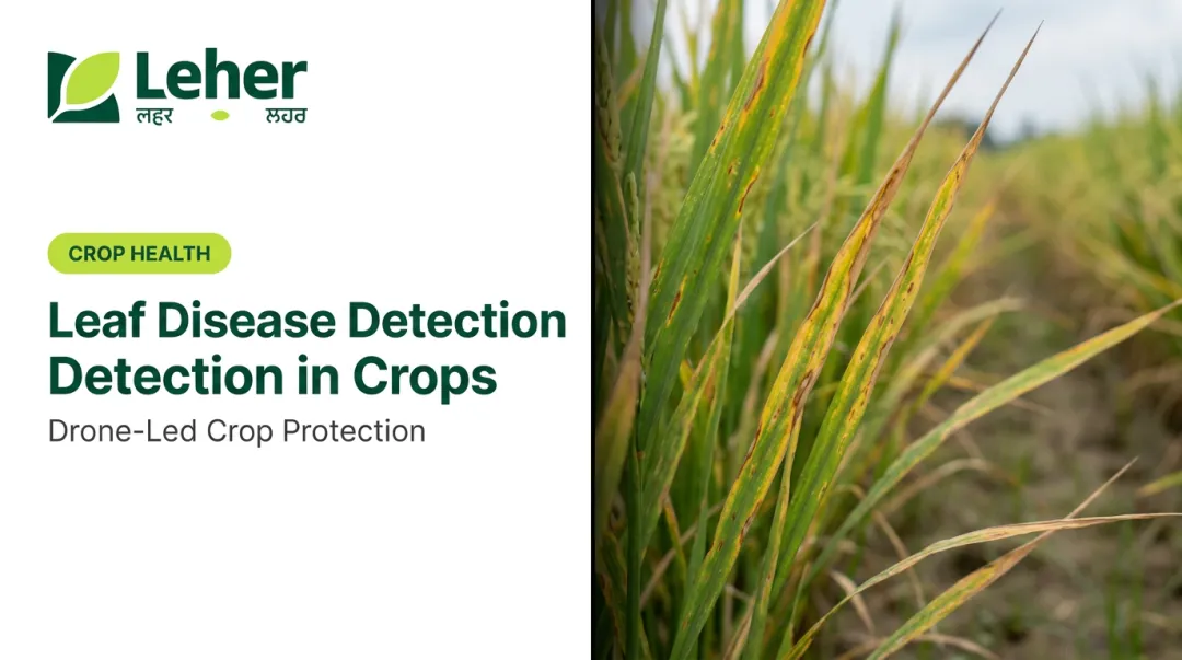
What are common signs of poor crop health that farmers should watch for?
Watch for these warning signs:
- Yellowing or discoloured leaves — often signals nutrient deficiency
- Wilting despite adequate rainfall — may indicate water stress or root disease
- Spots or lesions on leaves and stems — typically fungal or bacterial infection
- Patchy, uneven growth or stunted plants across sections of the field
How do drones help in crop health monitoring?
Drones capture high-resolution multispectral imagery at the field level, detecting stress patterns earlier and more precisely than satellite passes allow. Once a problem area is identified, drone spraying can target that exact zone — making them especially practical for India's small, fragmented farm plots.
How often should crop health be monitored?
Monitor at every major crop growth stage as a minimum, with more frequent checks during high-risk periods — post-monsoon, flowering stage, and after weather events. IoT sensors and automated satellite alerts keep watch between active field inspections with minimal effort.